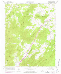
1967 Map of Covesville
USGS Topo · Published 1977About this map
Israel Mountain and the Fan Mountains dominate this central Virginia landscape, where small rural communities are tucked between prominent ridges and gaps. The Southern railroad provides the primary industrial artery, following the base of Cook Mountain through Covesville and North Garden. This survey, updated in the mid-1970s, captures a transition in land use, showing traditional country churches like Bethel Ch and Mt Ed Ch alongside more contemporary infrastructure like the Observatory near Mt Oliver. The distribution of cemeteries, such as the Wild Rose Cem, and landmarks like the Lookout Tower on Heard Mtn illustrate the long-standing human presence in this topography. Along the South Fork Hardware River and its numerous branches, the map details the intricate relationship between the region's steep elevations and its agricultural valleys.
Find a feature on this map
58 named features on this map. Tap any name to fly to it.
Don’t see what you’re looking for? This feature index may not catch every label — zoom into the map to look around manually.
Map Details
Editions of this 1967 Covesville Map
3 editions found
Other maps of this area

1892 · Buckingham
USGS Topo · 1:125,000

1892 · Harrisonburg
USGS Topo · 1:125,000

1929 · Covesville
USGS Topo · 1:62,500

1931 · University
USGS Topo · 1:62,500

1934 · Waynesboro
USGS Topo · 1:48,000

1935 · Covesville
USGS Topo · 1:62,500

1935 · University
USGS Topo · 1:62,500

1939 · Waynesboro
USGS Topo · 1:62,500

1943 · Lovingston
USGS Topo · 1:62,500

1945 · Covesville
USGS Topo · 1:62,500