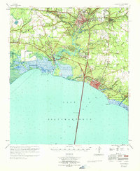
1969 Map of Covington
USGS Topo · Published 1971About this map
The Tchefuncta River anchors the landscape of this St. Tammany Parish survey, winding past Madisonville and the expansive Fairview Riverside State Park before emptying into the lake. The era's transportation network is defined by the massive Lake Pontchartrain Causeway stretching south from Lewisburg, while the Illinois Central railroad connects the established town of Covington with Abita Springs.
Find a feature on this map
59 named features on this map. Tap any name to fly to it.
Don’t see what you’re looking for? This feature index may not catch every label — zoom into the map to look around manually.
Map Details
Editions of this 1969 Covington Map
This is the sole edition of this map. No revisions or reprints were ever made.
Other maps of this area

1891 · Spanish Fort
USGS Topo · 1:62,500

1892 · Chef Menteur
USGS Topo · 1:62,500

1892 · Bonnet Carre
USGS Topo · 1:62,500

1935 · Slidell
USGS Topo · 1:62,500

1935 · Covington
USGS Topo · 1:62,500

1935 · Ponchatoula
USGS Topo · 1:62,500

1936 · South Point
USGS Topo · 1:31,680

1936 · Bonnet Carre
USGS Topo · 1:62,500

1936 · Chef Menteur
USGS Topo · 1:62,500

1936 · Spanish Fort
USGS Topo · 1:62,500