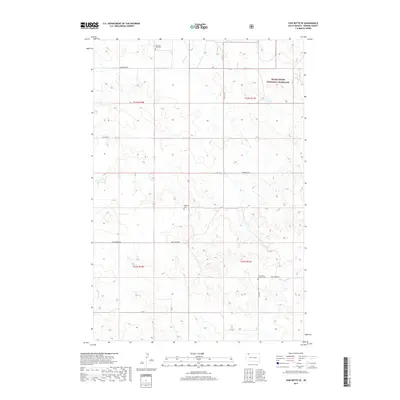
2017 Map of Cow Butte SE
USGS Topo · Published 2017About this map
Grand River National Grassland dominates the northeastern corner of this Perkins County landscape, representing a significant area of public prairie management. The terrain is defined by the dendritic drainage patterns of Horse Cr in the north and Duck Cr in the south, which carve through the high plains. This map is particularly valuable for genealogical research, as it identifies several rural burial sites that serve as anchors for early settlement history, including Ellingson Zion Cem near the northern boundary and the Duck Creek Lutheran Cem further south. A sparse network of gravel and dirt routes like Ellingson Rd and Duck Creek Rd connects these isolated landmarks, following the section lines established by the Public Land Survey System across Township 21 and 22 North.
Find a feature on this map
18 named features on this map. Tap any name to fly to it.
Don’t see what you’re looking for? This feature index may not catch every label — zoom into the map to look around manually.
Map Details
Editions of this 2017 Cow Butte SE Map
This is the sole edition of this map. No revisions or reprints were ever made.
Other maps of this area

1954 · Lemmon
USGS Topo · 1:250,000

1957 · Lemmon
USGS Topo · 1:250,000

1974 · Hettinger South
USGS Topo · 1:24,000

1974 · Cow Butte
USGS Topo · 1:24,000

1974 · Cow Butte NE
USGS Topo · 1:24,000

1983 · Cow Butte SE
USGS Topo · 1:24,000

1983 · Prairie City NE
USGS Topo · 1:24,000
1983 · Prairie City NW
USGS Topo · 1:24,000

1983 · Little Nasty Creek
USGS Topo · 1:24,000
1983 · Cow Butte SW
USGS Topo · 1:24,000