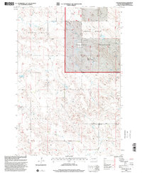
1998 Map of Cow Butte SE
USGS Topo · Published 2001About this map
Grand River National Grassland dominates the eastern half of this Perkins County landscape, representing a significant portion of the region's managed prairie. The map details a rural livestock and farming economy at the end of the 20th century, characterized by widely spaced homesteads such as the K Kuang Ranch and G Shiller Ranch. The settlement of Ellingson and surrounding areas are anchored by small community nodes including the Duck Creek Ch and its neighboring Duck Creek Sch. These landmarks, along with the Zion Cem and Bethany Cem, provide essential anchor points for genealogists tracing family footprints in this corner of South Dakota. The drainage patterns of Horse Creek and Duck Creek define the topography, illustrating the essential relationship between water sources and ranching life in the Great Plains.
Find a feature on this map
16 named features on this map. Tap any name to fly to it.
Don’t see what you’re looking for? This feature index may not catch every label — zoom into the map to look around manually.
Map Details
Editions of this 1998 Cow Butte SE Map
This is the sole edition of this map. No revisions or reprints were ever made.
Other maps of this area

1954 · Lemmon
USGS Topo · 1:250,000

1957 · Lemmon
USGS Topo · 1:250,000

1974 · Hettinger South
USGS Topo · 1:24,000

1974 · Cow Butte
USGS Topo · 1:24,000

1974 · Cow Butte NE
USGS Topo · 1:24,000

1983 · Cow Butte SE
USGS Topo · 1:24,000

1983 · Prairie City NE
USGS Topo · 1:24,000
1983 · Prairie City NW
USGS Topo · 1:24,000

1983 · Little Nasty Creek
USGS Topo · 1:24,000
1983 · Cow Butte SW
USGS Topo · 1:24,000