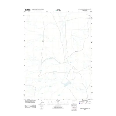
2012 Map of Cow Creek Reservoir
USGS Topo · Published 2012About this map
Shell Cr meanders through the high desert of Sweetwater County, forming a hydrological spine for a landscape defined by isolated water management. This area is characterized by a high density of named impoundments, such as Cow Creek Reservoir and State Reservoir Number 2, which suggest a critical reliance on seasonal water capture for livestock or land management. Topographic landmarks like Five Monument Butte provide navigational anchors in a region otherwise dominated by drainages and secondary roads. The distribution of sites like Petrified Wood Reservoir, Mosquito Reservoir, and Stormy Reservoir reflects the naming conventions of those working this land, marking specific features across the arid terrain. Infrastructure is sparse, primarily consisting of the Adobie Town Rim Rd and BLM Road 4412, highlighting the rural and utilitarian nature of this part of Wyoming.
Find a feature on this map
15 named features on this map. Tap any name to fly to it.
Don’t see what you’re looking for? This feature index may not catch every label — zoom into the map to look around manually.
Map Details
Editions of this 2012 Cow Creek Reservoir Map
This is the sole edition of this map. No revisions or reprints were ever made.
Other maps of this area

1954 · Rock Springs
USGS Topo · 1:250,000

1958 · Rock Springs
USGS Topo · 1:250,000

1962 · Rock Springs
USGS Topo · 1:250,000

1968 · Chicken Creek East
USGS Topo · 1:24,000

1968 · Sand Butte Rim SE
USGS Topo · 1:24,000
1968 · Chicken Creek SE
USGS Topo · 1:24,000

1970 · Cow Creek Reservoir
USGS Topo · 1:24,000
1970 · Kinney Spring
USGS Topo · 1:24,000

1970 · Manuel Gap
USGS Topo · 1:24,000
1970 · Upper Powder Spring
USGS Topo · 1:24,000