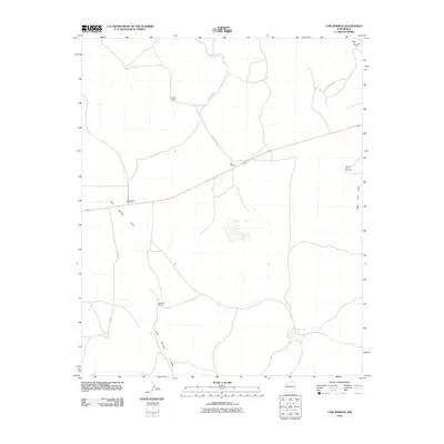
2010 Map of Cow Springs
USGS Topo · Published 2010About this map
Goude Ranch and Brockman Ranch anchor this landscape of the High Plains, where water management defines the pattern of human settlement. The 2010 topography shows a network of drainage features like Mayes Wash and Cow Springs Draw that cross the terrain toward the south and west. Scattered water sources, critical for ranching operations in this arid region, include the Cow Springs Windmill, East Windmill, and Vicente Baca Windmill. In the southern portion of the quadrangle, ephemeral basins like Chihuahua Lake and Cout Lake collect seasonal runoff. Access to these remote homesteads is maintained by a sparse road network, primarily County Rd A004 and Dove Valley Rd, which navigate the gentle slopes between Red Hill Draw and the various cattle tanks.
Find a feature on this map
12 named features on this map. Tap any name to fly to it.
Don’t see what you’re looking for? This feature index may not catch every label — zoom into the map to look around manually.
Map Details
Editions of this 2010 Cow Springs Map
This is the sole edition of this map. No revisions or reprints were ever made.
Other maps of this area

1886 · St Johns
USGS Topo · 1:250,000

1892 · St Johns
USGS Topo · 1:250,000

1954 · Saint Johns
USGS Topo · 1:250,000

1955 · Red Hill
USGS Topo · 1:24,000

1957 · Saint Johns
USGS Topo · 1:250,000

1958 · Saint Johns
USGS Topo · 1:250,000

1962 · Saint Johns
USGS Topo · 1:250,000
1968 · Nelson Reservoir NE
USGS Topo · 1:24,000
1968 · Loco Knoll
USGS Topo · 1:24,000
1971 · The Rincon
USGS Topo · 1:24,000