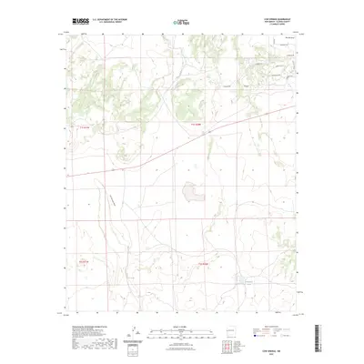
2023 Map of Cow Springs
USGS Topo · Published 2023About this map
Cow Springs serves as a focal point for this arid high-altitude landscape in western New Mexico, where seasonal water sources dictate the layout of the land. The topography is defined by significant drainages including Cow Springs Draw, Mayes Wash, and Red Hill Draw, which cut through the high-elevation terrain typical of the Colorado Plateau transition. In the northeastern portion of the sheet, the residential development at Cimerron is marked by a network of local roads such as Chamisa Trl and Cimmeron Dr, indicating modern settlement patterns in an area traditionally used for ranching. Further south, Chihuahua Lake and the natural landmark of Cowboy Pass stand out as rare features in a region characterized by vast sections of open ranch land and rugged canyons.
Find a feature on this map
19 named features on this map. Tap any name to fly to it.
Don’t see what you’re looking for? This feature index may not catch every label — zoom into the map to look around manually.
Map Details
Editions of this 2023 Cow Springs Map
This is the sole edition of this map. No revisions or reprints were ever made.
Other maps of this area

1886 · St Johns
USGS Topo · 1:250,000

1892 · St Johns
USGS Topo · 1:250,000

1954 · Saint Johns
USGS Topo · 1:250,000

1955 · Red Hill
USGS Topo · 1:24,000

1957 · Saint Johns
USGS Topo · 1:250,000

1958 · Saint Johns
USGS Topo · 1:250,000

1962 · Saint Johns
USGS Topo · 1:250,000
1968 · Nelson Reservoir NE
USGS Topo · 1:24,000
1968 · Loco Knoll
USGS Topo · 1:24,000
1971 · The Rincon
USGS Topo · 1:24,000