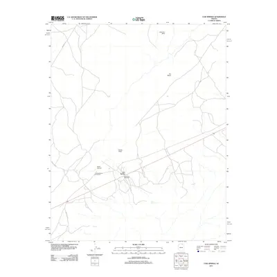
2011 Map of Cow Springs
USGS Topo · Published 2011About this map
Cow Springs serves as the focal point for this high-desert region, where the intersection of trade and geography is clearly defined by the Old Cow Springs Trading Post and the newer Cow Springs Trading Post. The landscape is dominated by significant plateaus and drainage systems, including the broad Wild Man Mesa to the north and Two Mesas to the east. The terrain drops into the Klethla Valley, a corridor shaped by ancient geological forces and seasonal watercourses. Local water sources, critical in this arid environment, are marked by features like Reed Spring, Maittoh, and Kai Si Kato. The presence of several tribal routes, such as Indian Rte-16 and Indian Rte-6270, highlights the enduring importance of this area as a crossroads for travel and commerce in the early 21st century.
Find a feature on this map
13 named features on this map. Tap any name to fly to it.
Don’t see what you’re looking for? This feature index may not catch every label — zoom into the map to look around manually.
Map Details
Editions of this 2011 Cow Springs Map
This is the sole edition of this map. No revisions or reprints were ever made.
Other maps of this area

1883 · Marsh Pass
USGS Topo · 1:250,000

1892 · Marsh Pass
USGS Topo · 1:250,000

1956 · Marble Canyon
USGS Topo · 1:250,000

1959 · Marble Canyon
USGS Topo · 1:250,000

1961 · Marble Canyon
USGS Topo · 1:250,000

1970 · Cow Springs
USGS Topo · 1:24,000
1970 · Kydestea Spring
USGS Topo · 1:24,000

1970 · Square Butte
USGS Topo · 1:24,000

1970 · Black Mesa Wash NW
USGS Topo · 1:24,000

1970 · Whirlwind Rock
USGS Topo · 1:24,000