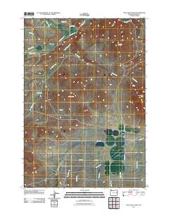
2011 Map of Cow Valley West
USGS Topo · Published 2011About this map
Bonita anchors the southern portion of this high-desert landscape in Malheur County, where the settlement pattern is dictated by the availability of water and the rise of prominent basaltic landmarks. The map documents an intricate drainage system including Cow Creek and Lyman Creek, alongside vital irrigation infrastructure like the Rutherford Ditch near Willow Creek. High points such as Worsham Butte and Cow Valley Butte overlook broad, arid expanses like Rye Flat and Lost Valley. The infrastructure shown, particularly Military Rd and Bonita Rd, reflects the historical transit corridors essential for ranching and movement through this part of the Oregon interior. Significant natural resources like Hugg Spring and the drainage of Indian Gulch highlight the environmental features that have sustained local operations in this sparsely populated region of eastern Oregon.
Find a feature on this map
26 named features on this map. Tap any name to fly to it.
Don’t see what you’re looking for? This feature index may not catch every label — zoom into the map to look around manually.
Map Details
Editions of this 2011 Cow Valley West Map
This is the sole edition of this map. No revisions or reprints were ever made.
Other maps of this area

1955 · Baker
USGS Topo · 1:250,000

1959 · Baker
USGS Topo · 1:250,000

1964 · Bridgeport
USGS Topo · 1:62,500

1964 · Brogan
USGS Topo · 1:62,500

1964 · Ironside
USGS Topo · 1:62,500

1966 · Clover Creek Ranch
USGS Topo · 1:62,500

1980 · Brogan
USGS Topo · 1:100,000
1990 · Brady Creek
USGS Topo · 1:24,000
1990 · Ironside
USGS Topo · 1:24,000
1990 · Scratch Post Butte
USGS Topo · 1:24,000