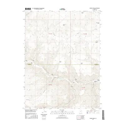
2017 Map of Cowboy Bench
USGS Topo · Published 2017About this map
Nine-Mile Cr winds through the heart of this landscape, carving a deep corridor that marks the historic boundary between Duchesne and Carbon counties. The terrain is defined by dramatic vertical relief, where the towering Bad Land Cliffs overlook expansive plateaus like Cowboy Bench and Spring Bench. This area is a network of named canyons including Prickly Pear Canyon, Daddy Canyon, and Cottonwood Canyon, each contributing to the complex geography of the greater Ninemile Canyon region.
Find a feature on this map
30 named features on this map. Tap any name to fly to it.
Don’t see what you’re looking for? This feature index may not catch every label — zoom into the map to look around manually.
Map Details
Editions of this 2017 Cowboy Bench Map
This is the sole edition of this map. No revisions or reprints were ever made.
Other maps of this area

1886 · Price River
USGS Topo · 1:250,000

1896 · Price River
USGS Topo · 1:250,000

1915 · Sunnyside
USGS Topo · 1:62,500

1954 · Flat Canyon
USGS Topo · 1:62,500

1956 · Price
USGS Topo · 1:250,000

1960 · Price
USGS Topo · 1:250,000

1962 · Price
USGS Topo · 1:250,000
1965 · Wilkin Ridge
USGS Topo · 1:24,000
1968 · Anthro Mtn NE
USGS Topo · 1:24,000
1968 · Cowboy Bench
USGS Topo · 1:24,000