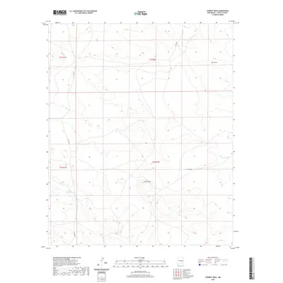
2020 Map of Cowboy Mesa
USGS Topo · Published 2020About this map
Cowboy Mesa rises as the central geographic landmark in this high-plains landscape of Lincoln County, characterized by a sparse network of ranching infrastructure and seasonal water drainages. The mapping reveals a reliance on water management in this arid environment, evidenced by named catchments like Clarence Tank and the meandering path of the Cola del Gallo Arroyo. The land is divided into township and range grids, with travel primarily facilitated by rural routes such as Co RD b020 and Co RD b021. Wide natural depressions like Buck Draw and Corn Draw define the local topography, indicating the subtle but critical flow of water across this expansive New Mexico terrain. This record provides a clear view of the area's rural development and hydrologic features as they were documented in 2020.
Find a feature on this map
11 named features on this map. Tap any name to fly to it.
Don’t see what you’re looking for? This feature index may not catch every label — zoom into the map to look around manually.
Map Details
Editions of this 2020 Cowboy Mesa Map
This is the sole edition of this map. No revisions or reprints were ever made.
Other maps of this area

1954 · Fort Sumner
USGS Topo · 1:250,000

1955 · Roswell
USGS Topo · 1:250,000

1958 · Fort Sumner
USGS Topo · 1:250,000

1958 · Roswell
USGS Topo · 1:250,000

1962 · Roswell
USGS Topo · 1:250,000

1967 · Chivata Canyon
USGS Topo · 1:24,000

1967 · Ramon
USGS Topo · 1:24,000

1967 · Ramon SW
USGS Topo · 1:24,000

1979 · Fort Sumner
USGS Topo · 1:100,000
1979 · Salt Creek
USGS Topo · 1:100,000