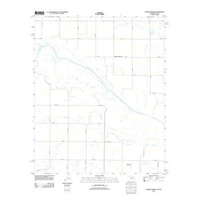
2012 Map of Cowboy Springs
USGS Topo · Published 2012About this map
The Red River defines the sweeping border landscape between Oklahoma and Texas, weaving a braided path through a region dominated by agriculture and rural infrastructure. Near the center of this 2012 survey, Cowboy Springs sits amidst a network of section-line roads, illustrating the persistent grid-based settlement pattern of the southern plains. The presence of Taylor Corner Gin points to the continued importance of cotton processing in this borderland economy, while the Mc Alister Farm Airport in the south provides evidence of the role of private aviation in managing large-scale farming operations. This landscape is also characterized by a complex drainage system, where tributaries like Adams Cr, Cooper Cr, and Suttle Cr feed into the primary river channel. These waterways and the straight-line roads like FM-370 and Mount Carmel Rd create a distinct geometry of natural curves against human-imposed order.
Find a feature on this map
22 named features on this map. Tap any name to fly to it.
Don’t see what you’re looking for? This feature index may not catch every label — zoom into the map to look around manually.
Map Details
Editions of this 2012 Cowboy Springs Map
This is the sole edition of this map. No revisions or reprints were ever made.
Other maps of this area

1915 · Barwise School
USGS Topo · 1:24,000

1916 · Electra
USGS Topo · 1:24,000

1918 · Electra
USGS Topo · 1:31,680

1918 · Barwise School
USGS Topo · 1:31,680

1955 · Lawton
USGS Topo · 1:250,000

1958 · Davidson
USGS Topo · 1:62,500

1958 · Frederick
USGS Topo · 1:62,500

1958 · Electra
USGS Topo · 1:62,500
1972 · Electra
USGS Topo · 1:24,000
1972 · Sunshine Hill
USGS Topo · 1:24,000