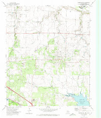
1972 Map of Sunshine Hill
USGS Topo · Published 1975About this map
The rugged Sunshine Hill landscape in northern Texas is defined by a dense network of petroleum extraction and strategic water management. In the early 1970s, the extensive Oil Field dominates the central terrain, with countless Oil Wells scattered across the drainages of Cole Creek and Long Creek. The presence of Tenth Cavalry Creek in the northeast hints at the region's historic military frontier associations, while the border with Tillman County, Oklahoma, is marked by the winding path of the Red River. To the south, the Fort Worth and Denver railroad serves the small settlement of Fowlkes, providing a critical link for the area's industrial output. The engineering of the North Fork Buffalo Creek Reservoir reflects mid-century efforts to stabilize water resources in this arid environment, creating a distinct recreational and utility hub near the local Campground.
Find a feature on this map
21 named features on this map. Tap any name to fly to it.
Don’t see what you’re looking for? This feature index may not catch every label — zoom into the map to look around manually.
Map Details
Editions of this 1972 Sunshine Hill Map
This is the sole edition of this map. No revisions or reprints were ever made.
Other maps of this area

1915 · Clara
USGS Topo · 1:24,000

1915 · Barwise School
USGS Topo · 1:24,000

1916 · Electra
USGS Topo · 1:24,000

1916 · Iowa Park
USGS Topo · 1:24,000

1916 · Fowlkes
USGS Topo · 1:24,000

1917 · Beaver Creek
USGS Topo · 1:24,000

1918 · Electra
USGS Topo · 1:31,680

1918 · Barwise School
USGS Topo · 1:31,680

1918 · Clara
USGS Topo · 1:31,680

1918 · Iowa Park
USGS Topo · 1:31,680