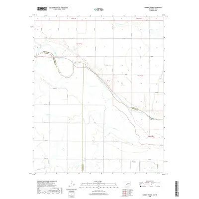
2018 Map of Cowboy Springs
USGS Topo · Published 2018About this map
The Red River serves as the defining border between Oklahoma and Texas on this 2018 survey, carving a wide path through the southern plains. This particular stretch highlights the intersection of Tillman County, Oklahoma, with Wilbarger and Wichita Counties in Texas. The landscape is characterized by its agricultural layout, marked by a dense network of sectional roads such as N 2230 RD and E 1920 RD. A notable aviation landmark, the Mc Alister Farm Airport, sits near the southern edge of the sheet, while named water features like Adams Cr and Cowboy Springs illustrate the local drainage into the river basin. The transition from the higher plains to the river bottom is documented through precise contour lines, showing the subtle topographic shifts that define this rural borderland.
Find a feature on this map
42 named features on this map. Tap any name to fly to it.
Don’t see what you’re looking for? This feature index may not catch every label — zoom into the map to look around manually.
Map Details
Editions of this 2018 Cowboy Springs Map
This is the sole edition of this map. No revisions or reprints were ever made.
Other maps of this area

1915 · Barwise School
USGS Topo · 1:24,000

1916 · Electra
USGS Topo · 1:24,000

1918 · Electra
USGS Topo · 1:31,680

1918 · Barwise School
USGS Topo · 1:31,680

1955 · Lawton
USGS Topo · 1:250,000

1958 · Davidson
USGS Topo · 1:62,500

1958 · Frederick
USGS Topo · 1:62,500

1958 · Electra
USGS Topo · 1:62,500
1972 · Electra
USGS Topo · 1:24,000
1972 · Sunshine Hill
USGS Topo · 1:24,000