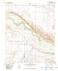
1984 Map of Cowboy Springs
USGS Topo · Published 1985About this map
The Red River corridor defines this borderland landscape between Oklahoma and Texas, where the shifting riverbed creates an Indefinite Boundary between Tillman Co and its neighbors to the south. The terrain is a network of drainage systems, including the westward-flowing Adams Creek and China Creek, alongside several smaller tributaries like Cooper Creek. Human activity is centered on the natural namesake of Cowboy Springs and the small settlement of Suttle. The map reveals a mid-century industrial presence marked by numerous wells and an Oil Well, connected by a prominent Pipeline that cuts across the southern portion of the survey area. Infrastructure such as a Substa and Storage Bins further indicate the region's focus on resource extraction and agricultural storage near the Oklahoma-Texas state line.
Find a feature on this map
19 named features on this map. Tap any name to fly to it.
Don’t see what you’re looking for? This feature index may not catch every label — zoom into the map to look around manually.
Map Details
Editions of this 1984 Cowboy Springs Map
This is the sole edition of this map. No revisions or reprints were ever made.
Other maps of this area

1915 · Barwise School
USGS Topo · 1:24,000

1916 · Electra
USGS Topo · 1:24,000

1918 · Electra
USGS Topo · 1:31,680

1918 · Barwise School
USGS Topo · 1:31,680

1955 · Lawton
USGS Topo · 1:250,000

1958 · Davidson
USGS Topo · 1:62,500

1958 · Frederick
USGS Topo · 1:62,500

1958 · Electra
USGS Topo · 1:62,500
1972 · Electra
USGS Topo · 1:24,000
1972 · Sunshine Hill
USGS Topo · 1:24,000