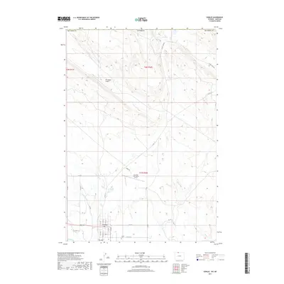
2017 Map of Cowley
USGS Topo · Published 2017About this map
Cowley serves as the central hub of this northern Big Horn County landscape, where the town grid meets a complex system of irrigation and drainage. The agricultural reliance on water is visible through features like Lateral D-56, Jensons Pond, and Peterson Cr, which branch across the high plains. To the north, the terrain becomes more distinct with the inclusion of Petroglyph Canyon, signaling the transition into the arid breaks near the state line. Transportation and local infrastructure are anchored by the North Big Horn County Airport and a network of county roads such as Co LN 8 and Gypsum Creek RD. Genealogy researchers will find the Cowley Cem located south of the main settlement near Big Wash. The geography is defined by seasonal watercourses like Dry Cr and Sage Creek, which carve through the landscape toward the Gup Reservoir.
Find a feature on this map
34 named features on this map. Tap any name to fly to it.
Don’t see what you’re looking for? This feature index may not catch every label — zoom into the map to look around manually.
Map Details
Editions of this 2017 Cowley Map
This is the sole edition of this map. No revisions or reprints were ever made.
Other maps of this area

1954 · Billings
USGS Topo · 1:250,000

1955 · Cody
USGS Topo · 1:250,000

1957 · Billings
USGS Topo · 1:250,000

1958 · Billings
USGS Topo · 1:250,000

1958 · Cody
USGS Topo · 1:250,000

1962 · Cody
USGS Topo · 1:250,000

1964 · Red Pryor Mountain
USGS Topo · 1:24,000

1964 · Lovell Lakes
USGS Topo · 1:24,000

1964 · Sykes Spring
USGS Topo · 1:24,000
1964 · Mystery Cave
USGS Topo · 1:24,000