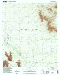
1996 Map of Cowlic
USGS Topo · Published 2002About this map
The Tohono O'odham Indian Reservation landscape is defined by its wide desert basins and sharp mountain ridges, as shown in this 1996 planimetric update. The settlement of Cowlic sits near the base of the Vamori Mts, while the eastern portion of the map is dominated by the steep rises of the Artesa Mountains. Water management is central to the area's geography, with the broad Fresnal Wash and Vamori Wash cutting through the La Mora Valley. Near the southern edge of the survey, the village of Topawa and the habitation area at Vopolo Havoka are located along the valley floor. Evidence of smaller-scale land use appears in the form of a Cem, several isolated wells, and a Landing Strip northwest of Cowlic. The map identifies both current settlements and the Vopolo Havoka (Site), suggesting a shifting pattern of occupation in this arid environment.
Find a feature on this map
15 named features on this map. Tap any name to fly to it.
Don’t see what you’re looking for? This feature index may not catch every label — zoom into the map to look around manually.
Map Details
Editions of this 1996 Cowlic Map
This is the sole edition of this map. No revisions or reprints were ever made.
Other maps of this area

1941 · Vamori
USGS Topo · 1:62,500

1941 · Sells
USGS Topo · 1:62,500

1943 · Sells
USGS Topo · 1:62,500

1943 · Fresnal
USGS Topo · 1:125,000

1943 · Vamori
USGS Topo · 1:62,500

1954 · Sonoyta
USGS Topo · 1:250,000

1956 · Nogales
USGS Topo · 1:250,000

1958 · Nogales
USGS Topo · 1:250,000

1959 · Nogales
USGS Topo · 1:250,000

1963 · Gu Oidak
USGS Topo · 1:62,500