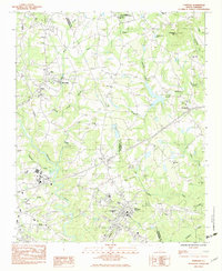
1983 Map of Cowpens
USGS Topo · Published 1983About this map
Cowpens National Battlefield anchors the northern portion of this landscape, marking a critical site along the Spartanburg and Cherokee county line. The map reveals a region defined by its waterway-driven development, from the Mayo Mills industrial site on Island Creek to the broad path of the Pacolet River in the south. Several rural congregations and community centers like Love Springs Ch, Cannons Campground Ch, and Graham Chapel serve as essential landmarks for genealogists tracing local family histories. The presence of the Seaboard and Southern railroads underscores the importance of the rail network in moving goods and people through settlements like Cowpens and Mayo. Topographically, the area is punctuated by Thicketty Mtn and its namesake Thicketty Mtn Lake, providing a clear view of the Piedmont terrain before late 20th-century expansion changed the character of these small Upstate South Carolina communities.
Find a feature on this map
39 named features on this map. Tap any name to fly to it.
Don’t see what you’re looking for? This feature index may not catch every label — zoom into the map to look around manually.
Map Details
Editions of this 1983 Cowpens Map
2 editions found
Other maps of this area

1909 · Gaffney
USGS Topo · 1:62,500

1941 · Spartanburg
USGS Topo · 1:250,000

1947 · Spartanburg
USGS Topo · 1:62,500

1949 · Spartanburg
USGS Topo · 1:24,000

1949 · Spartanburg
USGS Topo · 1:62,500

1953 · Spartanburg
USGS Topo · 1:250,000

1953 · Charlotte
USGS Topo · 1:250,000

1954 · Charlotte
USGS Topo · 1:250,000

1959 · Cowpens
USGS Topo · 1:62,500

1960 · Charlotte
USGS Topo · 1:250,000