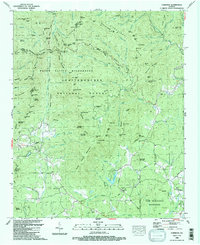
1988 Map of Cowrock
USGS Topo · Published 1988About this map
Raven Cliffs Wilderness and the surrounding reaches of the Chattahoochee National Forest dominate this late-twentieth-century landscape. The map details the convergence of Lumpkin Co, Union Co, and White Co amidst a high-elevation network of gaps and ridges. Historic transportation routes like the Logan Turnpike and the Appalachian Trail cross the terrain, linking remote gaps such as Tesnatee Gap and Hogpen Gap. Rural life is centered on small community landmarks, including Antioch Ch and Antioch Cem, while the southern reaches show scattered development along Town Creek and the vicinity of Loudsville Ch. The drainage patterns are intricate, with the Chattahoochee River and Dukes Creek carving through the mountain gaps, punctuated by features like Dukes Creek Falls.
Find a feature on this map
133 named features on this map. Tap any name to fly to it.
Don’t see what you’re looking for? This feature index may not catch every label — zoom into the map to look around manually.
Map Details
Editions of this 1988 Cowrock Map
2 editions found
Other maps of this area

1886 · Dahlonega
USGS Topo · 1:125,000

1892 · Dahlonega
USGS Topo · 1:125,000

1896 · Dahlonega
USGS Topo · 1:125,000

1903 · Dahlonega
USGS Topo · 1:125,000

1935 · Coosa Bald
USGS Topo · 1:24,000

1935 · Cowrock
USGS Topo · 1:24,000

1935 · Tray Mountain
USGS Topo · 1:24,000

1935 · Jacks Gap
USGS Topo · 1:24,000
1935 · Neels Gap
USGS Topo · 1:24,000

1938 · Cowrock
USGS Topo · 1:24,000