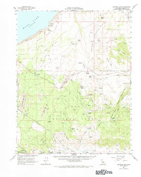
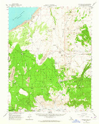
1962 Map of Cowtrack Mtn
USGS Topo · Published 1971About this map
Mono Basin serves as the focal point for this mid-century study of the eastern Sierra foothills, where the transition from high desert to volcanic peaks is clearly defined. The map records a landscape shaped by both timber history and modern water infrastructure, most notably the Mono Mills (Site) and the Old Railroad Grade that once served the Bodie mines. Evidence of the region’s hydraulic importance is visible through the Mono Aqueduct Tunnel and Mono Tunnel, linking the basin’s waters to distant urban needs.
Find a feature on this map
45 named features on this map. Tap any name to fly to it.
Don’t see what you’re looking for? This feature index may not catch every label — zoom into the map to look around manually.
Map Details
Editions of this 1962 Cowtrack Mtn Map
2 editions found
Other maps of this area

1901 · Mt. Lyell
USGS Topo · 1:125,000

1909 · Hawthorne
USGS Topo · 1:250,000

1909 · Bridgeport
USGS Topo · 1:125,000

1911 · Bridgeport
USGS Topo · 1:125,000

1911 · Hawthorne
USGS Topo · 1:250,000

1914 · Mt. Morrison
USGS Topo · 1:125,000

1915 · Hawthorne
USGS Topo · 1:250,000

1920 · Bridgeport
USGS Topo · 1:125,000

1947 · Mariposa
USGS Topo · 1:250,000

1948 · Walker Lake
USGS Topo · 1:250,000