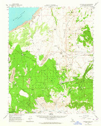
1962 Map of Cowtrack Mtn
USGS Topo · Published 1964About this map
Mono Basin and the volcanic terrain of the Mono Craters dominate this mid-century survey of the eastern Sierra region. The map documents a landscape heavily influenced by regional water management, featuring the Aqueduct, the Mono Tunnel, and the Mono Craters Tunnel, which serve as critical infrastructure for the Los Angeles Water District. To the east, the high elevations of Cowtrack Mountain and Granite Mountain rise above the Big Sand Flat, while the lower elevations are marked by the presence of Inyo National Forest.
Find a feature on this map
38 named features on this map. Tap any name to fly to it.
Don’t see what you’re looking for? This feature index may not catch every label — zoom into the map to look around manually.
Map Details
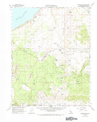
Editions of this 1962 Cowtrack Mtn Map
2 editions found
Other maps of this area

1901 · Mt. Lyell
USGS Topo · 1:125,000

1909 · Hawthorne
USGS Topo · 1:250,000

1909 · Bridgeport
USGS Topo · 1:125,000

1911 · Bridgeport
USGS Topo · 1:125,000

1911 · Hawthorne
USGS Topo · 1:250,000

1914 · Mt. Morrison
USGS Topo · 1:125,000

1915 · Hawthorne
USGS Topo · 1:250,000

1920 · Bridgeport
USGS Topo · 1:125,000

1947 · Mariposa
USGS Topo · 1:250,000

1948 · Walker Lake
USGS Topo · 1:250,000