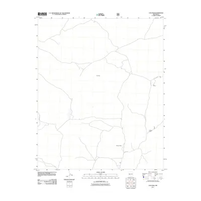
2011 Map of Cox Peak
USGS Topo · Published 2011About this map
Cox Peak commands the skyline of this high-altitude landscape in western New Mexico, overlooking a network of drainages and ranching infrastructure. The terrain is defined by dry watercourses such as Flying V Draw and Z Slash Draw, which suggest a seasonal hydrology typical of the region. Evidence of cattle ranching and water management is visible at the Raino Windmill, a critical landmark for local navigation and land use. The area is intersected by several remote access routes, including Saulsberry Rd and Greens Gap Rd, which connect the isolated peaks and draws to the broader Forest Service network via Forest Rd 63. This map preserves the 2011 layout of this quiet corner of Catron County.
Find a feature on this map
7 named features on this map. Tap any name to fly to it.
Don’t see what you’re looking for? This feature index may not catch every label — zoom into the map to look around manually.
Map Details
Editions of this 2011 Cox Peak Map
This is the sole edition of this map. No revisions or reprints were ever made.
Other maps of this area

1954 · Saint Johns
USGS Topo · 1:250,000

1954 · Socorro
USGS Topo · 1:250,000

1957 · Saint Johns
USGS Topo · 1:250,000

1958 · Socorro
USGS Topo · 1:250,000

1958 · Saint Johns
USGS Topo · 1:250,000

1962 · Socorro
USGS Topo · 1:250,000

1962 · Saint Johns
USGS Topo · 1:250,000
1964 · Madre Mountain
USGS Topo · 1:24,000

1964 · Crosby Springs
USGS Topo · 1:24,000
1965 · Sugarloaf Mountain
USGS Topo · 1:24,000