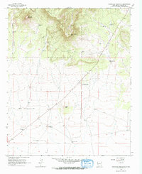
1965 Map of Sugarloaf Mountain
USGS Topo · Published 1967About this map
Cibola National Forest encompasses the northern high ground of this mid-1960s survey, where Sugarloaf Mountain and South Crosby Peak dominate the Crosby Mountains. The landscape transitions from these steep summits into a high plateau defined by livestock water management, evidenced by numerous named wells and windmills such as the Sugarloaf Windmill and Rock House West Windmill. A single settlement, Gutierrezville, serves as a human anchor in the central portion of the map near the Greens Gap Road.
Find a feature on this map
26 named features on this map. Tap any name to fly to it.
Don’t see what you’re looking for? This feature index may not catch every label — zoom into the map to look around manually.
Map Details
Editions of this 1965 Sugarloaf Mountain Map
This is the sole edition of this map. No revisions or reprints were ever made.
Other maps of this area

1918 · Pelona
USGS Topo · 1:125,000

1954 · Tularosa
USGS Topo · 1:250,000

1954 · Clifton
USGS Topo · 1:250,000

1954 · Saint Johns
USGS Topo · 1:250,000

1954 · Socorro
USGS Topo · 1:250,000

1957 · Clifton
USGS Topo · 1:250,000

1957 · Saint Johns
USGS Topo · 1:250,000

1958 · Socorro
USGS Topo · 1:250,000

1958 · Clifton
USGS Topo · 1:250,000

1958 · Tularosa
USGS Topo · 1:250,000