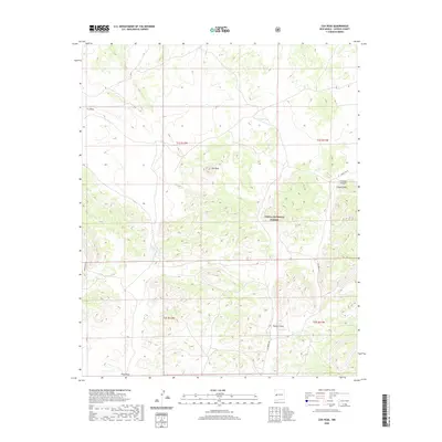
2020 Map of Cox Peak
USGS Topo · Published 2020About this map
Cox Peak stands as the central topographic focal point in this high-elevation landscape within the Cibola National Forest. The 2020 terrain is defined by a complex network of seasonal drainages and draws that carve through the Catron County highlands, reflecting the importance of water management in this arid environment. Ranching and land-use patterns are evident through named water features like Flats Tank and Cox Lake, as well as the naming conventions of natural features like Z Slash Canyon and Z Slash Draw. Access to this remote section of New Mexico is provided by established backcountry routes including Greens Gap Rd and Saulsberry Rd. The presence of Jones Spring and Nester Draw suggests a history of localized water sources critical for livestock and wildlife, while the landscape remains largely unsettled, dominated by natural contours and forest boundaries.
Find a feature on this map
18 named features on this map. Tap any name to fly to it.
Don’t see what you’re looking for? This feature index may not catch every label — zoom into the map to look around manually.
Map Details
Editions of this 2020 Cox Peak Map
This is the sole edition of this map. No revisions or reprints were ever made.
Other maps of this area

1954 · Saint Johns
USGS Topo · 1:250,000

1954 · Socorro
USGS Topo · 1:250,000

1957 · Saint Johns
USGS Topo · 1:250,000

1958 · Socorro
USGS Topo · 1:250,000

1958 · Saint Johns
USGS Topo · 1:250,000

1962 · Socorro
USGS Topo · 1:250,000

1962 · Saint Johns
USGS Topo · 1:250,000
1964 · Madre Mountain
USGS Topo · 1:24,000

1964 · Crosby Springs
USGS Topo · 1:24,000
1965 · Sugarloaf Mountain
USGS Topo · 1:24,000