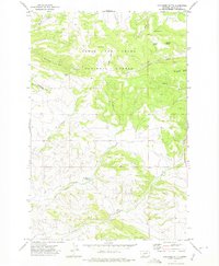
1971 Map of Coxcombe Butte
USGS Topo · Published 1975About this map
Lewis and Clark National Forest encompasses the northern half of this terrain, where the prominent Coxcombe Butte stands as a central landmark. The landscape is defined by a dense network of water sources and drainage systems, including Whitetail Deer Creek and Little Sheep Creek. In the southern portion of the quadrangle, the Buckingham Reservoir and the winding course of Newlan Creek indicate the significance of water management for the surrounding ranching or agricultural lands. The presence of several named springs, such as Buffalo Spring, Butterfly Spring, and Horsefly Spring, highlights the critical importance of reliable water points in this part of Meagher County. Evidence of local industry is sparse but present, noted by a Gravel Pit located near the boundary between Meagher Co and Park Co.
Find a feature on this map
20 named features on this map. Tap any name to fly to it.
Don’t see what you’re looking for? This feature index may not catch every label — zoom into the map to look around manually.
Map Details
Editions of this 1971 Coxcombe Butte Map
This is the sole edition of this map. No revisions or reprints were ever made.
Other maps of this area

1886 · Fort Logan
USGS Topo · 1:250,000

1886 · Little Belt Mts.
USGS Topo · 1:250,000

1894 · Little Belt Mts.
USGS Topo · 1:250,000

1897 · Little Belt Mts.
USGS Topo · 1:250,000

1898 · Little Belt Mts.
USGS Topo · 1:250,000

1902 · Little Belt Mts.
USGS Topo · 1:250,000

1948 · White Sulphur Springs
USGS Topo · 1:250,000

1958 · White Sulphur Springs
USGS Topo · 1:250,000

1961 · White Sulphur Springs
USGS Topo · 1:250,000

1965 · White Sulphur Springs
USGS Topo · 1:250,000