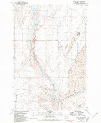
1981 Map of Coyote Butte
USGS Topo · Published 1981About this map
Thavis (Site) and Mack (Site) represent the former settlement footprint along the border of Washington-Adams Co in this 1981 survey. The landscape is defined by the ephemeral water systems of Union Pacific Creek and Coyote Lake, where numerous wells such as Well 480 and Well 458 indicate a continued reliance on groundwater for the local cattle industry. A distinctive Corral near the Ralston Road and Thavis site underscores the agricultural utility of the region.
Find a feature on this map
30 named features on this map. Tap any name to fly to it.
Don’t see what you’re looking for? This feature index may not catch every label — zoom into the map to look around manually.
Map Details
Editions of this 1981 Coyote Butte Map
This is the sole edition of this map. No revisions or reprints were ever made.
Other maps of this area

1923 · Washtucna
USGS Topo · 1:62,500

1925 · Washtucna
USGS Topo · 1:62,500

1950 · Benge
USGS Topo · 1:62,500

1952 · Benge
USGS Topo · 1:62,500

1953 · Walla Walla
USGS Topo · 1:250,000

1953 · Ritzville
USGS Topo · 1:250,000

1958 · Walla Walla
USGS Topo · 1:250,000

1959 · Ritzville
USGS Topo · 1:250,000

1964 · Macall
USGS Topo · 1:24,000

1964 · Marengo
USGS Topo · 1:24,000