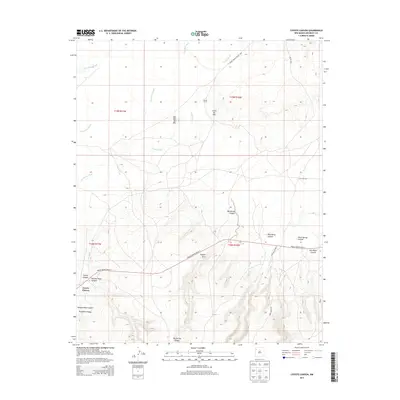
2013 Map of Coyote Canyon
USGS Topo · Published 2013About this map
Coyote Canyon anchors this high-desert landscape in McKinley County, where the topography is defined by a dense network of washes and deep canyons. The settlement is positioned at the intersection of Navajo Service Route 9 and a network of unpaved tracks, including the Kerr Maggie Rd and Old Crpt Rd. Notable geological landmarks like the Coyote Arch and peaks such as Dzil Nda Kai Mtn and Little Ear Mtn rise above the drainage systems of Coyote Wash and Figueredo Wash. The southern portion of the survey is characterized by intricate canyon systems, including Window Rock Canyon, Pumpkin Canyon, and Peach Spring Canyon. This 2013 data provides a modern record of the roads and natural features within the Fort Defiance Agency area, documenting the persistence of traditional place names alongside modern service routes.
Find a feature on this map
23 named features on this map. Tap any name to fly to it.
Don’t see what you’re looking for? This feature index may not catch every label — zoom into the map to look around manually.
Map Details
Editions of this 2013 Coyote Canyon Map
This is the sole edition of this map. No revisions or reprints were ever made.
Other maps of this area

1886 · Wingate
USGS Topo · 1:250,000

1892 · Wingate
USGS Topo · 1:250,000

1954 · Gallup
USGS Topo · 1:250,000

1958 · Gallup
USGS Topo · 1:250,000

1959 · Gallup
USGS Topo · 1:250,000

1962 · Gallup
USGS Topo · 1:250,000

1963 · Big Rock Hill
USGS Topo · 1:24,000
1963 · Hard Ground Flats
USGS Topo · 1:24,000
1963 · Oak Spring
USGS Topo · 1:24,000

1967 · Gallup
USGS Topo · 1:250,000