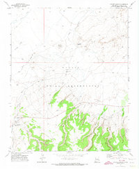
1970 Map of Coyote Canyon
USGS Topo · Published 1974About this map
Coyote Canyon (Brimhall PO) serves as the primary settlement hub within the sprawling Navajo Indian Reservation, situated near the confluence of several prominent drainages. The landscape is defined by its deep incisions and vertical relief, ranging from the broad reaches of Coyote Wash and Red Willow Wash to the dramatic peaks of Dzil Nda Kai Mountain and Little Ear Mountain. Evidence of much earlier habitation is present, marked by a Cliff Dwelling and various Ruins tucked into the canyon walls, particularly around Peach Spring Canyon and Wild Berry Canyon. This 1970 field-checked survey reveals a mix of traditional land use and modern infrastructure, including Sewage Disposal Ponds and a network of wells like Black Spot Well, supporting the local community at the foot of the Defiance Plateau.
Find a feature on this map
25 named features on this map. Tap any name to fly to it.
Don’t see what you’re looking for? This feature index may not catch every label — zoom into the map to look around manually.
Map Details
Editions of this 1970 Coyote Canyon Map
This is the sole edition of this map. No revisions or reprints were ever made.
Other maps of this area

1886 · Wingate
USGS Topo · 1:250,000

1892 · Wingate
USGS Topo · 1:250,000

1954 · Gallup
USGS Topo · 1:250,000

1958 · Gallup
USGS Topo · 1:250,000

1959 · Gallup
USGS Topo · 1:250,000

1962 · Gallup
USGS Topo · 1:250,000

1963 · Big Rock Hill
USGS Topo · 1:24,000
1963 · Hard Ground Flats
USGS Topo · 1:24,000
1963 · Oak Spring
USGS Topo · 1:24,000

1967 · Gallup
USGS Topo · 1:250,000