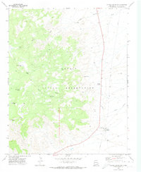
1970 Map of Coyote Canyon NW
USGS Topo · Published 1974About this map
Water sources define the geography of the Navajo Indian Reservation in this 1970 survey. The landscape is etched by seasonal drainages like Salt Springs Wash and Tocito Wash, which serve as the primary topographical markers in this arid stretch of McKinley County. For genealogists and local historians, the specific naming of remote watering points provides essential context for land use and habitation patterns. Numerous named springs are documented, including White Water Spring, Piñon Spring, Loca Spring, and Buffalo Springs. Human infrastructure is sparse but critical, evidenced by the Gallup Pumping Sta and its associated pipeline, as well as a Radio Facility located near Willow Reed Spring. The map captures a moment when traditional Navajo territory relied heavily on these scattered natural and engineered water points.
Find a feature on this map
17 named features on this map. Tap any name to fly to it.
Don’t see what you’re looking for? This feature index may not catch every label — zoom into the map to look around manually.
Map Details
Editions of this 1970 Coyote Canyon NW Map
This is the sole edition of this map. No revisions or reprints were ever made.
Other maps of this area

1886 · Wingate
USGS Topo · 1:250,000

1889 · Chaco
USGS Topo · 1:250,000

1892 · Wingate
USGS Topo · 1:250,000

1892 · Chaco
USGS Topo · 1:250,000

1954 · Shiprock
USGS Topo · 1:250,000

1954 · Gallup
USGS Topo · 1:250,000

1955 · Tohatchi
USGS Topo · 1:62,500

1958 · Gallup
USGS Topo · 1:250,000

1958 · Shiprock
USGS Topo · 1:250,000

1959 · Shiprock
USGS Topo · 1:250,000
Featured Places
- Fort Defiance Agency
- Buffalo Springs, Fort Defiance Agency
- Buffalo Springs, Fort Defiance Agency
- McKinley County, NM
- United States