
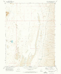
2020 Map of Coyote Knolls
USGS Topo · Published 2020About this map
Coyote Knolls rise from the expansive floor of the Tule Valley in this topographic survey of Millard County. The landscape is defined by its isolation and the stark geography of the eastern Great Basin, where subtle elevation changes and seasonal wetland patches are the primary markers on the terrain. The map detail reflects the Public Land Survey System boundaries for t15.5s r16w and t15.5s r15w, illustrating the geometric division of the arid West. While largely devoid of permanent settlements or infrastructure, the sheet tracks a network of local roads and 4WD tracks that provide the only access through this desolate valley environment.
Find a feature on this map
4 named features on this map. Tap any name to fly to it.
Don’t see what you’re looking for? This feature index may not catch every label — zoom into the map to look around manually.
Map Details
Editions of this 2020 Coyote Knolls Map
This is the sole edition of this map. No revisions or reprints were ever made.
Other maps of this area

1908 · Fish Springs
USGS Topo · 1:250,000

1910 · Fish Springs
USGS Topo · 1:250,000

1953 · Delta
USGS Topo · 1:250,000

1958 · Delta
USGS Topo · 1:250,000

1959 · Cowboy Pass
USGS Topo · 1:62,500

1960 · Granite Mountain
USGS Topo · 1:62,500

1962 · Delta
USGS Topo · 1:250,000

1967 · Sand Pass
USGS Topo · 1:24,000

1972 · Swasey Peak SW
USGS Topo · 1:24,000
1972 · Swasey Peak NW
USGS Topo · 1:24,000