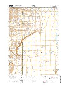
2014 Map of Coyote Lake West
USGS Topo · Published 2014About this map
Coyote Lake and the arid eastern expanse of Oregon define this landscape along the boundary shared by Harney Co and Malheur Co. The terrain is characterized by broad alkali flats and isolated water sources, most notably the Lower Willow Creek Waterhole and the level geography of The Flats. Towards the southeastern corner, the prominent Twin Buttes rise above the surrounding basin. This survey illustrates the sparse infrastructure typical of the high desert, where travel is dictated by routes such as Coyote Lk. The map provides a clear look at the public land survey system grid, including townships t34s r36e, t34s r37e, t35s r36e, and t35s r37e, which overlay a region defined by its significant hydrographic features and minimal human settlement.
Find a feature on this map
10 named features on this map. Tap any name to fly to it.
Don’t see what you’re looking for? This feature index may not catch every label — zoom into the map to look around manually.
Map Details
Editions of this 2014 Coyote Lake West Map
This is the sole edition of this map. No revisions or reprints were ever made.
Other maps of this area

1955 · Adel
USGS Topo · 1:250,000

1957 · Adel
USGS Topo · 1:250,000

1958 · Adel
USGS Topo · 1:250,000

1962 · Adel
USGS Topo · 1:250,000

1981 · Coyote Lake West
USGS Topo · 1:24,000
1981 · Grassy Ridge Well
USGS Topo · 1:24,000
1981 · Coyote Lake East
USGS Topo · 1:24,000
1981 · Twelvemile Ridge
USGS Topo · 1:24,000

1981 · Tule Springs NE
USGS Topo · 1:24,000

1981 · Ancient Lake Well
USGS Topo · 1:24,000