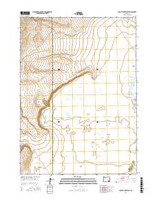
2017 Map of Coyote Lake West
USGS Topo · Published 2017About this map
The high desert landscape of eastern Oregon is defined by the stark expanse of Coyote Lake, a dry lakebed that dominates the eastern edge of this 2017 survey. This particular quadrangle captures the boundary between Harney and Malheur Counties, where the terrain transitions from the sparse elevation of Twin Buttes to the broad, level reaches of The Flats. The land is mapped according to the Public Land Survey System, marked by township and range lines such as t34s r36e and t35s r37e. The topography is characterized by subtle elevation changes and wide basins, typical of the Great Basin’s northern reaches, providing a clear view of the drainage patterns and desert geography that have shaped ranching and land use in this isolated corner of the state.
Find a feature on this map
8 named features on this map. Tap any name to fly to it.
Don’t see what you’re looking for? This feature index may not catch every label — zoom into the map to look around manually.
Map Details
Editions of this 2017 Coyote Lake West Map
This is the sole edition of this map. No revisions or reprints were ever made.
Other maps of this area

1955 · Adel
USGS Topo · 1:250,000

1957 · Adel
USGS Topo · 1:250,000

1958 · Adel
USGS Topo · 1:250,000

1962 · Adel
USGS Topo · 1:250,000

1981 · Coyote Lake West
USGS Topo · 1:24,000
1981 · Grassy Ridge Well
USGS Topo · 1:24,000
1981 · Coyote Lake East
USGS Topo · 1:24,000
1981 · Twelvemile Ridge
USGS Topo · 1:24,000

1981 · Tule Springs NE
USGS Topo · 1:24,000

1981 · Ancient Lake Well
USGS Topo · 1:24,000