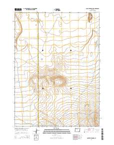
2014 Map of Coyote Meadows
USGS Topo · Published 2014About this map
Coyote Meadows lies along the high desert boundary between Harney and Malheur counties, a region defined by seasonal watercourses and prominent volcanic terrain. This 2014 survey documents the remote landscape where Whitehorse Cr and Antelope Cr drain through deep topographic contours toward the eastern basin. To the northeast, Twin Buttes rises above the surrounding plateau, providing a stark landmark against The Flats. The map traces vital access routes in this arid cattle-range country, including Whitehorse Rd and Crooked Creek Range Rd. The sparse distribution of named water sources like Twelvemile Cr and Fish Cr underscores the importance of these drainages for land management and historical ranching operations in the Oregon high desert.
Find a feature on this map
14 named features on this map. Tap any name to fly to it.
Don’t see what you’re looking for? This feature index may not catch every label — zoom into the map to look around manually.
Map Details
Editions of this 2014 Coyote Meadows Map
This is the sole edition of this map. No revisions or reprints were ever made.
Other maps of this area

1955 · Adel
USGS Topo · 1:250,000

1957 · Adel
USGS Topo · 1:250,000

1958 · Adel
USGS Topo · 1:250,000

1962 · Adel
USGS Topo · 1:250,000

1981 · Coyote Lake West
USGS Topo · 1:24,000
1981 · Coyote Lake East
USGS Topo · 1:24,000
1981 · Twelvemile Ridge
USGS Topo · 1:24,000

1981 · Tule Springs NE
USGS Topo · 1:24,000

1981 · Miranda Flat SE
USGS Topo · 1:24,000
1981 · Dry Creek Bench
USGS Topo · 1:24,000