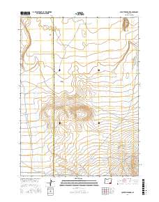
2017 Map of Coyote Meadows
USGS Topo · Published 2017About this map
Coyote Meadows and the high desert terrain of Malheur County define this remote corner of southeastern Oregon. The landscape is characterized by its drainage systems and subtle elevation changes, where seasonal watercourses like Whitehorse Cr, Antelope Cr, and Twelvemile Cr carve through the arid plains. Situated near the Harney County and Malheur County line, the area features prominent landmarks such as the Twin Buttes in the northeast and the broad expanse of The Flats. Grounded in a ranching and range-management environment, the map documents the essential connectivity of the region through throughfares like the Crooked Creek Range Rd and Whitehorse Rd. These roads provided critical access for local land use in an era of sparse settlement and high-elevation grazing lands.
Find a feature on this map
14 named features on this map. Tap any name to fly to it.
Don’t see what you’re looking for? This feature index may not catch every label — zoom into the map to look around manually.
Map Details
Editions of this 2017 Coyote Meadows Map
This is the sole edition of this map. No revisions or reprints were ever made.
Other maps of this area

1955 · Adel
USGS Topo · 1:250,000

1957 · Adel
USGS Topo · 1:250,000

1958 · Adel
USGS Topo · 1:250,000

1962 · Adel
USGS Topo · 1:250,000

1981 · Coyote Lake West
USGS Topo · 1:24,000
1981 · Coyote Lake East
USGS Topo · 1:24,000
1981 · Twelvemile Ridge
USGS Topo · 1:24,000

1981 · Tule Springs NE
USGS Topo · 1:24,000

1981 · Miranda Flat SE
USGS Topo · 1:24,000
1981 · Dry Creek Bench
USGS Topo · 1:24,000