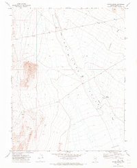
1971 Map of Coyote Spring
USGS Topo · Published 1973About this map
Dry Lake Valley dominates this 1970s landscape in Lincoln County, where the arid terrain is defined by drainage patterns and sparse water sources. The map centered around Coyote Spring illustrates a high-desert environment characterized by large alluvial washes such as Coyote Wash and Silverhorn Wash. These seasonal waterways converge toward a broad, low-lying basin marked as a depression at the southern edge of the sheet.
Find a feature on this map
8 named features on this map. Tap any name to fly to it.
Don’t see what you’re looking for? This feature index may not catch every label — zoom into the map to look around manually.
Map Details
Editions of this 1971 Coyote Spring Map
This is the sole edition of this map. No revisions or reprints were ever made.
Other maps of this area

1885 · Pioche
USGS Topo · 1:250,000

1886 · Pioche
USGS Topo · 1:250,000

1915 · Bristol Range
USGS Topo · 1:62,500

1916 · Highland
USGS Topo · 1:62,500

1917 · Bristol Range
USGS Topo · 1:62,500

1918 · Highland
USGS Topo · 1:62,500

1954 · Caliente
USGS Topo · 1:250,000

1956 · Lund
USGS Topo · 1:250,000

1959 · Caliente
USGS Topo · 1:250,000

1960 · Lund
USGS Topo · 1:250,000