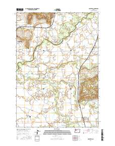
2017 Map of Crabtree
USGS Topo · Published 2017About this map
The North Santiam River and South Santiam River define the intricate hydrology of this Willamette Valley landscape. The settlement of Jefferson sits at the western edge, connected to its neighbors by a network of drainage ditches and historic sloughs, including Sidney Ditch and Lakeview Slough. The terrain is marked by prominent elevations such as Miller Butte in the north and the Salem Hills, while lower areas like McKinney Bottom and Independence Prairie show the region's agricultural character.
Find a feature on this map
92 named features on this map. Tap any name to fly to it.
Don’t see what you’re looking for? This feature index may not catch every label — zoom into the map to look around manually.
Map Details
Editions of this 2017 Crabtree Map
This is the sole edition of this map. No revisions or reprints were ever made.
Other maps of this area

1911 · Lebanon
USGS Topo · 1:31,680

1911 · Tangent
USGS Topo · 1:31,680

1912 · Jefferson
USGS Topo · 1:31,680

1915 · Sidney
USGS Topo · 1:31,680

1916 · Albany
USGS Topo · 1:62,500

1917 · Salem
USGS Topo · 1:62,500

1921 · Lebanon
USGS Topo · 1:62,500

1922 · Lebanon
USGS Topo · 1:48,000

1924 · Lebanon
USGS Topo · 1:62,500

1925 · Stayton
USGS Topo · 1:62,500