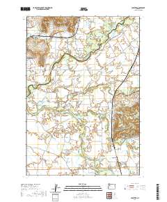
2020 Map of Crabtree
USGS Topo · Published 2020About this map
The North Santiam River and South Santiam River converge in this fertile Willamette Valley landscape, where the border between Marion Co and Linn Co is defined by the shifting watercourses. The agricultural legacy of the region is evident in the irrigation systems like Sidney Ditch and Jefferson Ditch, which support the farms surrounding Jefferson and Crabtree. Notable landforms such as Miller Butte and Hungry Hill rise above the alluvial plains of McKinney Bottom and Independence Prairie. Genealogists will find interest in the documented locations of Jefferson Cem and Central Cem, as well as the proximity of long-standing crossing points like Greens Bridge. The presence of several sloughs and reservoirs, including Wil-Lyn Reservoir and Sucker Slough, illustrates the complex hydrology required to manage the valley's drainage and water resources.
Find a feature on this map
93 named features on this map. Tap any name to fly to it.
Don’t see what you’re looking for? This feature index may not catch every label — zoom into the map to look around manually.
Map Details
Editions of this 2020 Crabtree Map
This is the sole edition of this map. No revisions or reprints were ever made.
Other maps of this area

1911 · Lebanon
USGS Topo · 1:31,680

1911 · Tangent
USGS Topo · 1:31,680

1912 · Jefferson
USGS Topo · 1:31,680

1915 · Sidney
USGS Topo · 1:31,680

1916 · Albany
USGS Topo · 1:62,500

1917 · Salem
USGS Topo · 1:62,500

1921 · Lebanon
USGS Topo · 1:62,500

1922 · Lebanon
USGS Topo · 1:48,000

1924 · Lebanon
USGS Topo · 1:62,500

1925 · Stayton
USGS Topo · 1:62,500