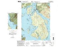
1997 Map of Craig A-3
USGS Topo · Published 2000About this map
Hydaburg serves as the primary settlement on this portion of Prince of Wales Island, situated along the sheltered waters of the Sukkwan Strait. The 1997 revision by the Forest Service highlights a landscape defined by complex maritime geography, where the Tongass National Forest meets the intricate shorelines of Tlevak Strait and Hetta Inlet. The map details local landmarks such as the Lighthouse Reserve on Goat Island and a Comm Tower near the town site.
Find a feature on this map
55 named features on this map. Tap any name to fly to it.
Don’t see what you’re looking for? This feature index may not catch every label — zoom into the map to look around manually.
Map Details
Editions of this 1997 Craig A-3 Map
This is the sole edition of this map. No revisions or reprints were ever made.
Other maps of this area

1948 · Craig A-4
USGS Topo · 1:63,360

1948 · Dixon Entrance D-2
USGS Topo · 1:63,360

1948 · Dixon Entrance D-4
USGS Topo · 1:63,360

1948 · Dixon Entrance D-3
USGS Topo · 1:63,360

1948 · Craig A-3
USGS Topo · 1:63,360

1948 · Craig A-2
USGS Topo · 1:63,360

1949 · Craig B-2
USGS Topo · 1:63,360

1949 · Craig B-3
USGS Topo · 1:63,360

1949 · Craig B-4
USGS Topo · 1:63,360

1951 · Craig B-2
USGS Topo · 1:63,360