
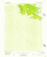
1948 Map of Dixon Entrance D-4
USGS Topo · Published 1957About this map
Waterfall Bay and Gold Harbor define the deeply indented shoreline of this coastal stretch within the Tongass National Forest. Surveyed shortly after the war, the map reveals a wilderness landscape where the coastal fringe of the Pacific Ocean meets steep terrain marked by Twin Peaks and numerous freshwater bodies like Lake Welcome and Waterfall Lake. The complex maritime geography is characterized by numerous navigation points and sheltered waters, including Augustine Bay, Gooseneck Harbor, and the small Camp Cove. While no roads or trails are recorded, the naming of features such as Welcome Pt and Cape Magdalena suggests the importance of this coastline for maritime passage and seasonal anchorage. Interior drainage is captured through a network of small lakes, notably Devil Lake and Little Devil Lake, which sit perched above the saltwater inlets.
Find a feature on this map
21 named features on this map. Tap any name to fly to it.
Don’t see what you’re looking for? This feature index may not catch every label — zoom into the map to look around manually.
Map Details
Editions of this 1948 Dixon Entrance D-4 Map
This is the sole edition of this map. No revisions or reprints were ever made.
Other maps of this area

1948 · Craig A-4
USGS Topo · 1:63,360

1948 · Dixon Entrance D-5
USGS Topo · 1:63,360

1948 · Craig A-5
USGS Topo · 1:63,360
1948 · Dixon Entrance C-3
USGS Topo · 1:63,360

1948 · Dixon Entrance D-3
USGS Topo · 1:63,360

1948 · Craig A-3
USGS Topo · 1:63,360

1951 · Dixon Entrance
USGS Topo · 1:250,000

1951 · Dixon Entrance D-3
USGS Topo · 1:63,360

1951 · Craig A-4
USGS Topo · 1:63,360

1951 · Craig A-3
USGS Topo · 1:63,360