
1948 Map of Dixon Entrance D-5
USGS Topo · Published 1957About this map
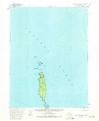
Forrester Island and its surrounding archipelago dominate this maritime survey, illustrating a remote outpost within the Tongass National Forest. The map documents a specific moment in the mid-20th century where the land was dual-designated as the Forrester Island National Wildlife Refuge. A notable human element is the Military Camp (Inactive) located near Eagle Harbor, signaling the area's strategic significance during earlier years. Further south, a solitary Cabin is marked on the eastern shore of the main island, suggesting a footprint of seasonal habitation or resource management. The coastline is defined by hazardous maritime features like Sea Lion Rock, Cape Horn Rocks, and North Rocks, while smaller landmasses such as Lowrie Island and Petrel Island extend the refuge's reach into the Pacific Ocean.
Find a feature on this map
15 named features on this map. Tap any name to fly to it.
Don’t see what you’re looking for? This feature index may not catch every label — zoom into the map to look around manually.
Map Details
Editions of this 1948 Dixon Entrance D-5 Map
2 editions found
Other maps of this area

1948 · Craig A-4
USGS Topo · 1:63,360

1948 · Craig A-5
USGS Topo · 1:63,360

1948 · Dixon Entrance D-4
USGS Topo · 1:63,360

1951 · Dixon Entrance
USGS Topo · 1:250,000

1951 · Craig A-4
USGS Topo · 1:63,360
1951 · Dixon Entrance D-4
USGS Topo · 1:63,360

1957 · Craig
USGS Topo · 1:250,000

1959 · Dixon Entrance
USGS Topo · 1:250,000
1994 · Craig A-4
USGS Topo · 1:63,360
2017 · Craig A-4 SW
USGS Topo · 1:25,000