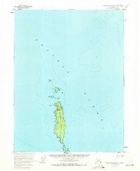
1948 Map of Dixon Entrance D-5
USGS Topo · Published 1972About this map
Forrester Island stands as the central landmark of this maritime survey, surrounded by the expanse of the Pacific Ocean. As part of the Forrester Island National Wildlife Refuge and Tongass National Forest, the island's isolation is underscored by its sparse human markings. A single Cabin is indicated on the eastern shore near Wood Cove, serving as a rare point of habitation or shelter in the late 1940s.
Find a feature on this map
18 named features on this map. Tap any name to fly to it.
Don’t see what you’re looking for? This feature index may not catch every label — zoom into the map to look around manually.
Map Details
Editions of this 1948 Dixon Entrance D-5 Map
2 editions found
Other maps of this area

1948 · Craig A-4
USGS Topo · 1:63,360

1948 · Dixon Entrance D-5
USGS Topo · 1:63,360

1948 · Craig A-5
USGS Topo · 1:63,360

1948 · Dixon Entrance D-4
USGS Topo · 1:63,360

1951 · Dixon Entrance
USGS Topo · 1:250,000

1951 · Craig A-4
USGS Topo · 1:63,360
1951 · Dixon Entrance D-4
USGS Topo · 1:63,360

1957 · Craig
USGS Topo · 1:250,000

1959 · Dixon Entrance
USGS Topo · 1:250,000
1994 · Craig A-4
USGS Topo · 1:63,360