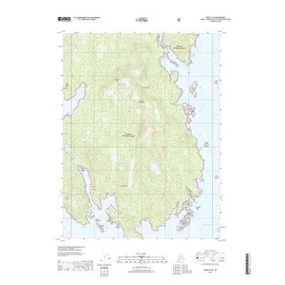
2017 Map of Craig A-3 SE
USGS Topo · Published 2017About this map
Sukkwan Island dominates this coastal survey within the Alexander Archipelago, showing a landscape defined by dramatic elevation changes and intricate shorelines. As part of the Tongass National Forest, the area is largely characterized by its natural features rather than human settlement, with freshwater bodies like Sukkwan Lake and Kasook Lake tucked into the interior heights. The maritime environment is documented through named coastal landmarks such as Round Point and the small Flat Island situated just off the eastern coast. To the south, Kasook Inlet carves into the island's landmass, while the eastern edge is bounded by the waters of Hetta Inlet, providing a clear record of the archipelago's complex geography as it met the Pacific Ocean in the early 21st century.
Find a feature on this map
17 named features on this map. Tap any name to fly to it.
Don’t see what you’re looking for? This feature index may not catch every label — zoom into the map to look around manually.
Map Details
Editions of this 2017 Craig A-3 SE Map
This is the sole edition of this map. No revisions or reprints were ever made.
Other maps of this area

1948 · Dixon Entrance D-2
USGS Topo · 1:63,360

1948 · Dixon Entrance D-3
USGS Topo · 1:63,360

1948 · Craig A-3
USGS Topo · 1:63,360

1948 · Craig A-2
USGS Topo · 1:63,360

1951 · Dixon Entrance
USGS Topo · 1:250,000

1951 · Dixon Entrance D-3
USGS Topo · 1:63,360

1951 · Dixon Entrance D-2
USGS Topo · 1:63,360

1951 · Craig A-2
USGS Topo · 1:63,360

1951 · Craig A-3
USGS Topo · 1:63,360

1957 · Craig
USGS Topo · 1:250,000