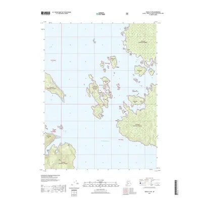
2017 Map of Craig A-3 SW
USGS Topo · Published 2017About this map
Tongass National Forest dominates this coastal landscape, covering the numerous islands and rugged shorelines of the Alexander Archipelago. Large landmasses like Dall Island are separated by the deep waters of Tlevak Strait, while smaller clusters such as the McFarland Islands and Reef Islands dot the maritime passages. The complex shoreline is defined by protected waters like View Cove, Baldy Bay, and Island Bay, providing natural harbors in a region primarily managed for its timber and wilderness values. Landforms such as Kellogg Point, Reef Point, and High Point serve as critical navigational landmarks for those traversing the Pacific Ocean entry points. This 2017 survey illustrates the intricate relationship between the temperate rainforest and the labyrinthine waterways of Prince of Wales-Hyder Census Area.
Find a feature on this map
19 named features on this map. Tap any name to fly to it.
Don’t see what you’re looking for? This feature index may not catch every label — zoom into the map to look around manually.
Map Details
Editions of this 2017 Craig A-3 SW Map
This is the sole edition of this map. No revisions or reprints were ever made.
Other maps of this area

1948 · Craig A-4
USGS Topo · 1:63,360

1948 · Dixon Entrance D-4
USGS Topo · 1:63,360

1948 · Dixon Entrance D-3
USGS Topo · 1:63,360

1948 · Craig A-3
USGS Topo · 1:63,360

1951 · Dixon Entrance
USGS Topo · 1:250,000

1951 · Dixon Entrance D-3
USGS Topo · 1:63,360

1951 · Craig A-4
USGS Topo · 1:63,360

1951 · Craig A-3
USGS Topo · 1:63,360
1951 · Dixon Entrance D-4
USGS Topo · 1:63,360

1957 · Craig
USGS Topo · 1:250,000