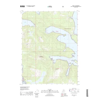
2017 Map of Craig A-4 SE
USGS Topo · Published 2017About this map
Tongass National Forest dominates this Alaskan coastal landscape, where deep saltwater inlets carve into the timbered slopes of Prince of Wales Island. The interconnected waterways of Tlevak Strait, Hook Arm, and Manhattan Arm characterize a complex shoreline that defined local maritime navigation and industry in the early 21st century. Further south, protected anchorages like View Cove and Coco Harbor sit tucked behind Clam Island, while the inland terrain rises sharply to the peaks of White Mtn and Squaw Mtn. Significant freshwater bodies, including Manhattan Lake and the remote Devil Lake, provide evidence of the glacial hydrology and steep drainage patterns inherent to this part of the Alexander Archipelago. This survey documents the intersection of vast federal forest lands with the jagged, island-strewn coast of the Prince of Wales-Hyder Census Area.
Find a feature on this map
21 named features on this map. Tap any name to fly to it.
Don’t see what you’re looking for? This feature index may not catch every label — zoom into the map to look around manually.
Map Details
Editions of this 2017 Craig A-4 SE Map
This is the sole edition of this map. No revisions or reprints were ever made.
Other maps of this area

1948 · Craig A-4
USGS Topo · 1:63,360

1948 · Dixon Entrance D-4
USGS Topo · 1:63,360

1948 · Dixon Entrance D-3
USGS Topo · 1:63,360

1948 · Craig A-3
USGS Topo · 1:63,360

1951 · Dixon Entrance
USGS Topo · 1:250,000

1951 · Dixon Entrance D-3
USGS Topo · 1:63,360

1951 · Craig A-4
USGS Topo · 1:63,360

1951 · Craig A-3
USGS Topo · 1:63,360
1951 · Dixon Entrance D-4
USGS Topo · 1:63,360

1957 · Craig
USGS Topo · 1:250,000