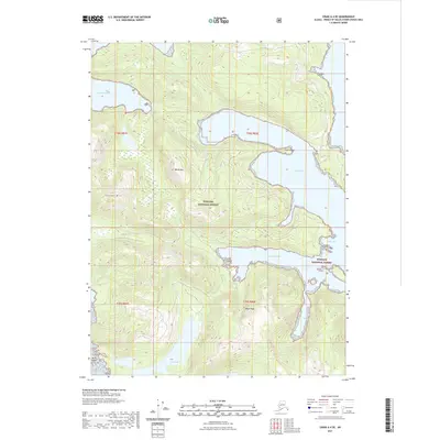
2021 Map of Craig A-4 SE
USGS Topo · Published 2021About this map
The Tongass National Forest dominates this coastal landscape in the Prince of Wales-Hyder area, where the Pacific coastline is deeply carved by numerous inlets and bays. Notable water features like the Manhattan Arm and View Cove punctuate the jagged shoreline, while Clam Island and Devil Island sit just off the coast. The interior is defined by significant elevations including Squaw Mtn, White Mtn, and Black Rock. This survey illustrates a complex maritime and mountain environment, showing the interaction between high peaks and deep tidal waters such as Green Inlet, Baldy Bay, and Coco Harbor. These features demonstrate the typical geological structure of the Alexander Archipelago, where steep terrain drops directly into the sea, creating sheltered spots like Windy Cove and freshwater features like Devil Lake just inland.
Find a feature on this map
17 named features on this map. Tap any name to fly to it.
Don’t see what you’re looking for? This feature index may not catch every label — zoom into the map to look around manually.
Map Details
Editions of this 2021 Craig A-4 SE Map
This is the sole edition of this map. No revisions or reprints were ever made.
Other maps of this area

1948 · Craig A-4
USGS Topo · 1:63,360

1948 · Dixon Entrance D-4
USGS Topo · 1:63,360

1948 · Dixon Entrance D-3
USGS Topo · 1:63,360

1948 · Craig A-3
USGS Topo · 1:63,360

1951 · Dixon Entrance
USGS Topo · 1:250,000

1951 · Dixon Entrance D-3
USGS Topo · 1:63,360

1951 · Craig A-4
USGS Topo · 1:63,360

1951 · Craig A-3
USGS Topo · 1:63,360
1951 · Dixon Entrance D-4
USGS Topo · 1:63,360

1957 · Craig
USGS Topo · 1:250,000