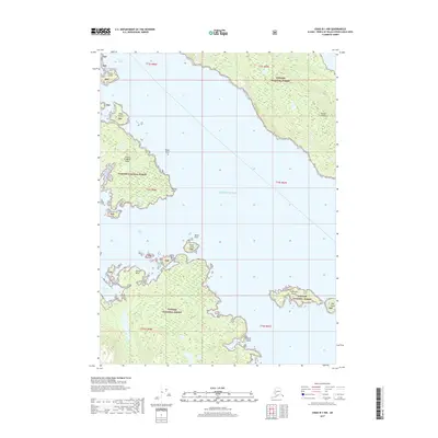
2017 Map of Craig B-1 NW
USGS Topo · Published 2017About this map
Prince of Wales Island and the neighboring Kasaan Peninsula dominate this coastal survey, where the intricate shoreline of Southeast Alaska meets the Pacific Ocean. This maritime landscape is defined by the massive Tongass National Forest, which covers the rugged islands and mainland peninsulas shown. Navigation through these waters involves threading the needle between several landforms, including Kasaan Island, Daisy Island, and the outcrop of Black Rock. To the south, the deep inlet of Skowl Arm carves into the island, sheltered by Skowl Island and Skowl Point. The map also captures smaller, isolated landmasses such as Patterson Island and High Island, alongside geographic markers like Giants Head and Saltery Cove. This 2017 edition document provides a clear view of the natural topography and protected federal lands as they appeared in the early 21st century.
Find a feature on this map
24 named features on this map. Tap any name to fly to it.
Don’t see what you’re looking for? This feature index may not catch every label — zoom into the map to look around manually.
Map Details
Editions of this 2017 Craig B-1 NW Map
This is the sole edition of this map. No revisions or reprints were ever made.
Other maps of this area

1949 · Craig C-2
USGS Topo · 1:63,360

1949 · Craig B-2
USGS Topo · 1:63,360

1949 · Craig B-1
USGS Topo · 1:63,360

1950 · Craig B-1
USGS Topo · 1:63,360

1950 · Craig C-1
USGS Topo · 1:63,360

1951 · Craig B-2
USGS Topo · 1:63,360

1951 · Craig C-2
USGS Topo · 1:63,360

1951 · Craig C-1
USGS Topo · 1:63,360

1957 · Craig
USGS Topo · 1:250,000
1994 · Craig C-2
USGS Topo · 1:63,360