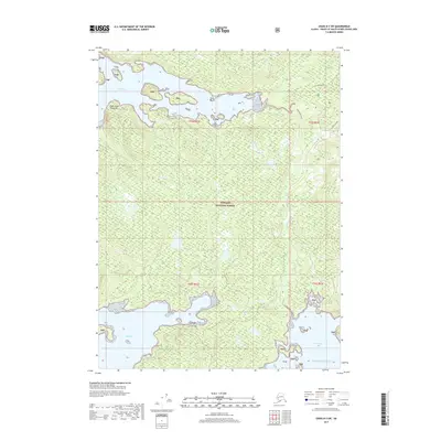
2017 Map of Craig B-3 SW
USGS Topo · Published 2017About this map
Tongass National Forest dominates this coastal landscape on Prince of Wales Island, where the intricate shoreline of the Pacific Ocean meets the dense timber of Southeast Alaska. The northern reach is defined by the waters of Trocadero Bay and the tidal expanse of Trocadero Flats, while to the south, Soda Bay cuts deep into the landmass near Point Saint Sebastian. This 2017 survey documents the vital transit corridors of the wilderness, including the Trocadero Trail and the route labeled Dog Salmon. These named paths and the presence of drainages like Soda Cr suggest the enduring importance of this terrain for both ecological preservation and local subsistence. The map provides a high-resolution view of the area's complex hydrology, from the small islands within the bays to the interior wetlands that characterize this part of the Alexander Archipelago.
Find a feature on this map
15 named features on this map. Tap any name to fly to it.
Don’t see what you’re looking for? This feature index may not catch every label — zoom into the map to look around manually.
Map Details
Editions of this 2017 Craig B-3 SW Map
This is the sole edition of this map. No revisions or reprints were ever made.
Other maps of this area

1948 · Craig A-4
USGS Topo · 1:63,360

1948 · Craig A-3
USGS Topo · 1:63,360

1949 · Craig B-3
USGS Topo · 1:63,360

1949 · Craig B-4
USGS Topo · 1:63,360

1951 · Craig B-4
USGS Topo · 1:63,360

1951 · Craig B-3
USGS Topo · 1:63,360

1951 · Craig A-4
USGS Topo · 1:63,360

1951 · Craig A-3
USGS Topo · 1:63,360

1957 · Craig
USGS Topo · 1:250,000
1994 · Craig A-4
USGS Topo · 1:63,360