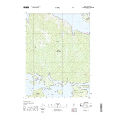
2017 Map of Craig B-4 SE
USGS Topo · Published 2017About this map
The Alexander Archipelago coastline of Prince of Wales Island is documented here as part of the Tongass National Forest. This maritime environment is defined by complex waterways, including the Tlevak Strait and the narrow passage of Tlevak Narrows, which separates the main landmass from Dall Island. The southern reaches of this survey highlight smaller landforms such as Shelikof Island, Midway Island, and Block Island, which cluster near the entrance to Soda Bay. To the north, the terrain rises toward Perlas Point and overlooks the sheltered waters of Big Bay and Trocadero Bay. This map provides a detailed view of the natural coastal geometry and island systems prior to recent shifts in maritime management and forest conservation efforts in this part of Alaska.
Find a feature on this map
22 named features on this map. Tap any name to fly to it.
Don’t see what you’re looking for? This feature index may not catch every label — zoom into the map to look around manually.
Map Details
Editions of this 2017 Craig B-4 SE Map
This is the sole edition of this map. No revisions or reprints were ever made.
Other maps of this area

1948 · Craig A-4
USGS Topo · 1:63,360

1948 · Craig A-3
USGS Topo · 1:63,360

1949 · Craig B-3
USGS Topo · 1:63,360

1949 · Craig B-4
USGS Topo · 1:63,360

1951 · Craig B-4
USGS Topo · 1:63,360

1951 · Craig B-3
USGS Topo · 1:63,360

1951 · Craig A-4
USGS Topo · 1:63,360

1951 · Craig A-3
USGS Topo · 1:63,360

1957 · Craig
USGS Topo · 1:250,000
1994 · Craig A-4
USGS Topo · 1:63,360