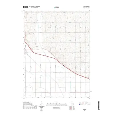
2021 Map of Craig
USGS Topo · Published 2021About this map
Craig serves as the primary settlement in this northwestern Missouri landscape, positioned at the edge of the Missouri River floodplain. The terrain is defined by the complex hydrology of the Tarkio valley, where the Old Channel Little Tarkio River and Old Channel Little Tarkio Cr reveal how the water has been managed or diverted over time. To the north and east, the land rises into dissected uplands drained by Wildcat Cr and Squaw Cr. Genealogical interest centers on the Independent Order of Odd Fellows Cem just outside the main townsite and the New Liberty Cem situated further east among the ridges. The map details a dense rural road network, including family-named routes like Frost Rd and Hagar Dr, which weave through the agricultural sections and connect isolated farmsteads to the regional thoroughfares of State Hwy N and State Hwy C.
Find a feature on this map
34 named features on this map. Tap any name to fly to it.
Don’t see what you’re looking for? This feature index may not catch every label — zoom into the map to look around manually.
Map Details
Editions of this 2021 Craig Map
This is the sole edition of this map. No revisions or reprints were ever made.
Other maps of this area

1920 · Craig
USGS Topo · 1:62,500

1926 · Maitland
USGS Topo · 1:62,500

1936 · Fairfax
USGS Topo · 1:24,000

1939 · Tarkio
USGS Topo · 1:62,500

1939 · Skidmore
USGS Topo · 1:62,500

1940 · Tarkio
USGS Topo · 1:62,500

1941 · Tarkio
USGS Topo · 1:62,500

1941 · Skidmore
USGS Topo · 1:62,500

1942 · Skidmore
USGS Topo · 1:62,500

1955 · Nebraska City
USGS Topo · 1:250,000