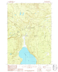
1986 Map of Craig Pass
USGS Topo · Published 1986About this map
Yellowstone National Park terrain is defined here by the winding spine of the Continental Divide, which separates the headwaters of the Snake and Madison river systems. The map centers on the high-elevation crossing at Craig Pass, where the unusual Isa Lake sits directly on the divide, famously draining toward both the Atlantic and Pacific oceans. To the south, the massive expanse of Shoshone Lake dominates the landscape, its northern shoreline accessed only by backcountry routes and several Footbridges crossing De Lacy Creek. The presence of the Cement mine and the Lockout landmark suggest early industrial and monitoring efforts in this protected wilderness. In the northern reaches, De Lacy Park and the cluster of De Lacy Lakes provide a look at the meadow and wetland systems that characterize the high plateau before the terrain drops toward the Shoshone basin.
Find a feature on this map
23 named features on this map. Tap any name to fly to it.
Don’t see what you’re looking for? This feature index may not catch every label — zoom into the map to look around manually.
Map Details
Editions of this 1986 Craig Pass Map
This is the sole edition of this map. No revisions or reprints were ever made.
Other maps of this area

1885 · Gallatin
USGS Topo · 1:125,000

1885 · Gallatin
USGS Topo · 1:125,000

1886 · Shoshone
USGS Topo · 1:125,000

1888 · Shoshone
USGS Topo · 1:125,000

1895 · Shoshone
USGS Topo · 1:125,000

1901 · Shoshone
USGS Topo · 1:125,000

1901 · Gallatin
USGS Topo · 1:125,000

1908 · Gallatin
USGS Topo · 1:125,000

1908 · Shoshone
USGS Topo · 1:125,000

1911 · Shoshone
USGS Topo · 1:125,000